Greetings Everyone,
We’ve returned to Peru to trek to the Incan ruins of Choquequirao, often referred to as “The Cradle of Gold”. It had been 18 years since we last visited this fascinating country and we were drawn once again by its rich archeological treasures, vibrant culture and fascinating wildlife. Our journey began in the former Incan capital of Cusco which you can now reach via a direct flight from Bogota, Colombia. The city has grown tremendously since our last visit and was bustling with festivities surrounding Cusco Day. Plaza de Armas, the main square, was packed with people who had come to watch the parade of local dancers and musicians dressed in colorful costumes. We were able to watch the proceedings from a restaurant balcony high above the throng of onlookers.
 |
| Cusco Day Dancers |
The next day we met the other members of our trekking group, Mark and Chris from Britain, Robin from Scotland and Victor our guide. On June 25th we drove westwards from Cusco for 6 hours to the start of our trek at Capuliyoc. From this vantage point, we could see the formidable Apurímac Canyon, one of the deepest in the world which we would have to cross to reach Choquequirao!
 |
| Apurímac Canyon |
This feat would take us 2 days starting with a 3600-foot descent that afternoon to our first campsite at Chiquiska.
 |
| Descending into Apurímac Canyon |
The following morning we continued our descent of another 1800 feet passing tall San Pedro Cactus and Prickly Pear Cactus before reaching the Apurímac River.
 |
Marc Approaching the Apurímac River
|
Fortunately, a new bridge had been built across the river to replace the one that had been swept away in 2011.
 |
| Bridge over the Apurímac River |
Here colorful Mitred Parakeets were feeding in the nearby trees, and Marc was able to get some photos.
 |
| Mitred Parakeet |
Now we had to climb out of the canyon and up a mere 6000 feet to the campground below Choquequirao! Fortunately, the trail was graded for horses and we could ascend steadily up switchbacks to the tiny village of Marampata where we stopped for lunch at the home of a local farmer.
 |
| Lunch Stop at Marampata |
We were entertained by the farmer's kittens, puppies, and chickens, all of whom wanted a taste of our meal.
 |
| Lunch! |
After lunch, we continued toward the campground getting our first glimpses of Choquequirao and its impressive series of terraces along the way.
 |
| Choquequirao Terraces |
By the time we arrived in camp, we were too tired to climb further to the ruins, so we rested up for a full day of exploration tomorrow. I was surprised at how many trekkers were camping here, including another group and many backpackers who unlike us, had to carry all their own gear. Most would return the way we had just come, but we would continue on along a 9-day route that would take us close to Machu Picchu.
 |
Choquequirao Campground
|
Early the next morning, we headed out to visit Choquequirao and climbed modestly to the main gate, but it was locked. We paused for group photos then Robin and I went around the gate, but the others squeezed through.
 |
| Let us in! |
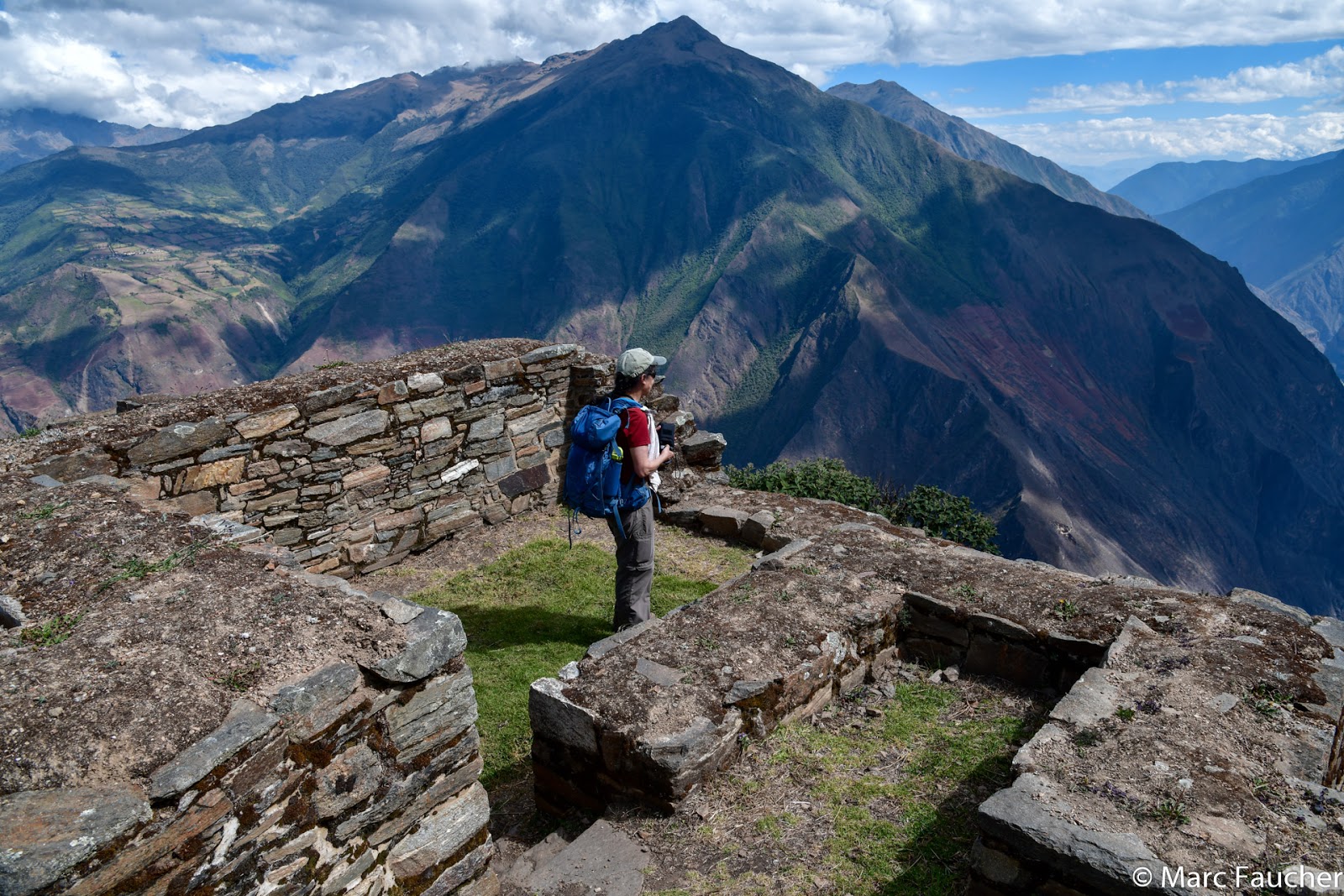
We entered an area of three large grassy terraces. Victor told us that camping used to be allowed here but backpackers would leave their trash, cut trees for campfires and remove rocks from the walls for fire rings. Fortunately, camping was banned in 2003 and the campground we were using was constructed nearby. Surprisingly, when we arrived at the central plaza, there were only a few other tourists considering the number staying at the campground. We decided to climb to the ceremonial platform to take pictures while the weather was clear and the lighting right. We scampered up and had a great view of the terraces we passed, the central plaza and the storehouses above.
 |
| Choquequirao from the Ceremonial Platform |
We returned to the main plaza where Victor gave us a history lesson. Choquequirao was built by the 11th Incan King, Pachacuti Inca Yupangui, in the latter years of the Incan empire from the 1490s to the 1520s. It was the last place of Incan resistance against the Spanish who never entered here but brought the mighty Incan Empire to an end in 1572. Choquequirao was rediscovered by Spanish explorer Juan Arias Díaz in 1710 and Hiram Bingham came in 1909, two years before he discovered Machu Picchu. At that time, the trail existed but Bingham and his mules had to cross the river by cable car.
Following our lecture, we visited the structures in the main plaza. Choquequirao is 75% original construction with only 25% restored. The first site was the “water place.” Water was very important to the Incas and it had three uses: drinking, irrigation, and ceremony. Stone-lined channels carried ceremonial water to shrines and baths throughout the site.
 |
| Water Channel |
We then visited the “mummy house” where important people we entombed in the fetal position to be reborn. Nearby were the 2-story Inca palaces where the upper caste lived.
 |
| Inca Palaces |
Next, we explored the “llama terraces” that were 1000 feet below the central plaza, first climbing down to a terrace decorated with a serpentine motif made with white quartzite. This style of design is uniquely Chachapoyan, another Andean culture that was conquered by the Incan Empire and believed to be involved in the construction of Choquequirao.
 |
| Chachapoyan Rock Art |
We continued down to the “llama terraces” where 25 llama figures had been built with the same white quartzite into the terrace walls. Llamas were the Incas' most important domestic animal, providing food, clothing and acting as beasts of burden. They were also often sacrificed in large numbers to the gods. We hiked out to a viewpoint from which we could see the entire set of terraces and its impressive rock art.
 |
"Llama Terraces"
|
 |
| Closeup of a Llama |
We climbed back up to the main plaza and continued up to the storehouses, the highest point of the site with spectacular views of the surrounding area.
 |
| Spectacular Views from Upper Storehouse |
We returned to the ceremonial platform from which we took a different trail down passing the “priests’ house” then down to Pikiwasi which means “flea house,” a collection of small houses and workshops.
 |
| Pikiwasi |
The following morning we visited sector XI of Choquequirao an impressive site called
Phaqchayuq ("the one with a waterfall") containing 80 terraces used for cultivation, which are the most extensive in the complex.
 |
| Choquequirao Waterfall Terraces |
Victor explained that the terraces were not made by cutting into the mountainside but by building a retaining wall and filling in behind it as shown in this diagram.
 |
| Terrace Construction |
The Incas used these terraces to form a stable place to grow crops such as potatoes, quinoa, and maize. The gardens were irrigated by aqueducts and canals, amazing feats of construction that still function today. Excavation of the site continues and is sure to unearth new archaeological surprises!
 |
| Excavation Still Underway |
We left Choquequirao and climbed further still to Choquequirao Pass and had our last views of “The Cradle of Gold.” After a few hours of walking, our group descended to another set of Incan ruins called Pincha Unuyoc and camped for the night.
 |
| Camp at Pincha Unuyoc |
Pincha Unuyoc was built about the same time as Choquequirao and it is believed to be primarily an agricultural site. We camped on the terraces of this secluded spot taking in the views and feeling the spirit of the Incans who resided here centuries before us.
 |
| Reflection |
The next morning we climbed 1900 feet down to the Rio Blanco and crossed on a rustic bridge.
 |
| Crossing the Rio Blanco |
We followed a rocky path along the bottom of the canyon and stopped for a break before starting up the 4000 feet of switchbacks to the tiny settlement of Maizal. There were many brightly colored butterflies along the way to distract us from the arduous climb.
 |
| Colorful Butterfly |
Across the valley, we could just make out the ruins at Pincha Unuyoc and the set of switchbacks we had taken down to the river.
 |
| View of Switchbacks from Maizal |
We reached Maizal around noon, a big descent (1900 feet) followed by an even bigger ascent (4100 feet) in just 4.5 hours! We settled into our tent in the afternoon for some well-deserved downtime. That evening, Victor pointed out the “black llama,” a void in the Milky Way in the shape of a llama. The eyes of the “black llama” are the two brightest stars in the Southern Hemisphere, Alpha Centauri, and Beta Centauri. Marc was unable to get a photo but we did find an illustration on the internet. I couldn’t help but feel another spiritual connection to the Inca.
 |
| Incan Constellations |
We were now more than halfway through our trek. The high mountain passes were yet to come. Stay tuned to see how we fare as we continue our trek from Choquequirao to Machu Picchu.
We hope all is well back home.
Peggy and Marc
Our route map:


No comments:
Post a Comment