Greetings Everyone,
Now that Spring had arrived in Vermont, we decided to head to the far north on May 30 to look for Narwhals and other Arctic animals. Our journey began with a 4-hour drive to Ottawa, Ontario where we spent our first night. The following morning we flew on First Air to the city of Iqaluit, the capital of the Canadian territory of Nunavut. Here we changed planes from a Boeing 737 to an ATR Turboprop to Clyde River where we stopped to refuel and then it was on to our final destination, Pond Inlet.
 |
Pond Inlet, Nunavut
|
Pond Inlet is a predominately Inuit community located on northern Baffin Island, the 5th largest island in the world. Most of the 1700 or so people living here work for the government or supplement their incomes by hunting and fishing. Ten polar bears per year are allowed to be taken by members of the community. However, a sign we saw in the post office indicated that the demand for polar bear pelts was down and that the government was no longer issuing advances on monthly income.
 |
| Notice in the Post Office |
Ringed seals and Narwhals are also hunted. We were here to hunt as well but with cameras and binoculars, not with rifles and harpoons. At this time of year the sun never sets and we had plenty of time to assemble our gear for a 6-day expedition to the floe edge where sea ice meets open ocean. We were given warm parkas, insulated rubber boots and warm sleeping bags. The next morning we loaded the Inuit-style qamutiks or wooden sleds with all our provisions including food, camp fuel, skis, gasoline for the snowmobiles, personal clothing and kayaks.
 |
| Loading the Qamutiks |
Camp had already been set up by the previous group on the floe edge about 40 miles away from town. We just had to reach it via a bumpy 3-hour snowmobile ride in the qamutiks. Marc and I were in the back of one being pulled by a snowmobile driven by our Canadian guides Steve and Ken and the other two clients, Sridhar and Martin, were in the other sled pulled by another snowmobile driven by our Inuit guide Gary. We cruised along Eclipse Sound, a narrow body of water (now frozen), separating Baffin Island from Bylot Island. The first part of our journey was quite bumpy but it was better to stand up than to sit down as you get jostled if seated. Besides we got a better view of the surrounding landscape.
 |
| Peggy on a Qamutik |
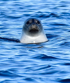
Ringed Seals were sunning themselves on the ice and would slide into their holes as we approached.
 |
| Ringed Seals on the Ice |
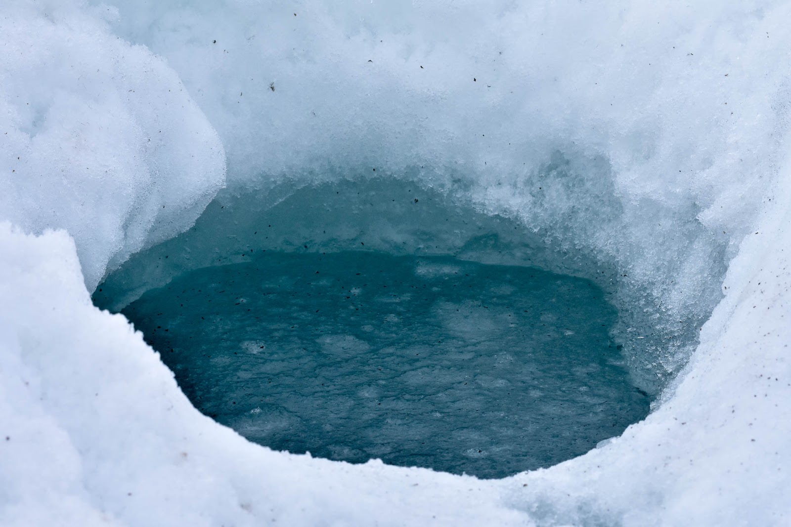
They are quite wary of humans as they are hunted for their meat and skins. They are also the favorite food of polar bears. I couldn't imagine living under the thick sea ice with only tiny holes through which to surface to breathe.
 |
| Seal Hole |
We arrived at camp around 1:30 and unloaded the qamutiks. Camp consisted of a large Mountain Hardwear dome tent called a Space Station. It would serve as the kitchen/dining tent. There were also five 2-man tents and a toilet tent. We settled into the tent closest to the Space Station.
 |
| Our Camp on the Ice |
After setting up camp we headed out on cross-country skis to explore the area. We were actually about 6 miles from the floe edge but decided not to visit it today. The last tour group had not been able to reach the edge and only recently had it opened to tourists. Conditions this year were somewhat unstable and the southern end had formed late so we were told to keep to the northern end. We didn't venture too far on skis and Ken told us to keep a lookout for polar bears. The last group had encountered one in this area while skiing. We saw its tracks but did not come across the bear.
 |
| Polar Bear Tracks Near Camp! |
The next morning we headed out to the floe edge. To reach it we had to cross a 3-foot wide crack in the ice. The technique we used was to disconnect the qatumik from the snowmobile so that it could muster speed and "fly" over the crack. Once on the other side, the sled would be reconnected and we'd be pulled gently across. I must admit that straddling a crack over the open Arctic Ocean was disconcerting at first but after a few crossings it became part of living on the edge.
 |
| Crossing the Crack! |
Success! We had reached the floe edge, among the first tourists of the season to do so! The floe edge is where the sea ice that is still attached to the land, having frozen over the winter months, meets the open ocean. We climbed a small iceberg to get a better view of this majestic realm. We looked out over the open Arctic Ocean stretching east as far as Greenland! In the springtime an abundance of arctic wildlife including walruses, seals, polar bears, narwhals, bowhead and beluga whales and a variety of birds gathers along the floe edge. We were hoping to spot some of these amazing creatures. Today only Thick-billed Murres, King and Common Eiders, Brant and Long-tailed Ducks bobbed on the rising swells.
 |
| King Eiders |
We set up our camp chairs to keep a lookout for the possible arrival of marine mammals. It was just another day on the " Arctic Beach".
 |
| Arctic Beach Goers |
We returned to the floe edge the next day in the hope of seeing some marine mammals a little further north near 2 massive icebergs.
 |
| Two Massive Icebergs |
After sitting patiently for hours we saw a few birds and an occasional Ringed Seal.
 |
| Ringed Seal |
The following day we decided to kayak in the Artic Ocean! We changed into drysuits with rubberized neck, wrist and ankle openings to keep water out in case you fell into the frigid water something I planned on not doing. I paired with Steve, Marc with Martin and Sridhar with Ken for our paddle. The water was calm as we paddled along an enormous iceberg. We kept our distance knowing that most (90%) of the berg was under the water and if a piece calved off we'd be swamped.
 |
| Peggy & Steve Kayaking |
We returned to "shore" after an exhilarating visit to one of the planets most extreme and seldom visited ecosystems! Martin was able to catch the scene from the air with his drone.
On our 5th day on the floe edge we visited some bird cliffs on Bylot Island. Here thousands of Black-legged Kittiwakes and Thick-billed Murres nest. Most breeding pairs had been established and had built their nests on narrow ledges along the cliff face. In 1965 the Bylot Island Migratory Bird Sanctuary was established to protect the nesting grounds of Thick-billed Murres, Black-legged Kittiwakes and Greater Snowgeese. More than 300,000 murres and 50,000 kittiwakes use this location each spring for breeding and rearing their chicks.
 |
| Nesting Black-legged Kittiwakes |
We noticed ropes hanging from the cliffs. We were told that the local Inuit use them to collect eggs. Even though Migratory Bird Sanctuaries (MBS's) were established for the protection and conservation of migratory birds, Nunavut beneficiaries have the right of access for the purpose of subsistence harvest.
 |
| Ropes Used by the Inuit to Collect Eggs |
We were seeing lots of birds but where were the whales? Our time on the floe edge was fast coming to an end. The following morning we were stunned to hear that the northern end of the floe edge had broken off! Just as Ken predicted, the large crack we had crossed everyday to reach the northern end of the floe edge had widen to the point where a massive chuck of ice had broken off and was now floating in the Arctic Ocean! We climbed to the top of Cape Graham Moore to get a better view and could see the large icebergs where we had spent so must time surrounded by open ocean!
 |
| View from Cape Graham Moore |
We had no choice but to head to the southern end of the ice floe. Other tour groups were there so the area must now be safe. No sooner had we arrived when we spotted our first Narwhal! It was an individual with a large scar on its side.
 |
| First Narwhal! |
We excitedly watched as he surfaced to breathe before diving to feed on fish and invertebrates. Narwhals are medium-sized toothed whales that live year round in the Arctic. They have been nicknamed "unicorns of the sea" owing to a long, straight helical tusk (actually an extension of the left canine) possessed by some of the males. We watched intently hoping to get a glimpse of a tusk but spotted only females with calves. One pair dove giving us a nice view of their tail flukes.
 |
| Narwhal Cow and Calf |
The global population of narwhals is estimated to be around 80,000 and they are classified as near-threatened. Despite this classification, the Inuit are allowed to hunt narwhals for subsistence purposes without restriction. I was surprised to learn that the locals only take the tusk, the skin and blubber called muktuk which is considered a delicacy and leave the rest of the carcass for scavengers. However the main threat to the narwhal is climate change causing rapidly shrinking ice cover. For a species that relies on sea ice for foraging and safety this could spell disaster. Even though we didn't see any males with tusks, observing females with calves was a rare privilege. I couldn't help wondering if the narwhals will be able to adapt to climate change fast enough or if humans will halt their destructive activities in time to save this iconic Arctic species.
All too soon it was time to leave the floe edge. Back in Pond Inlet we had time to visit the library where a life size model of a narwhal hung.
 |
| Model of a Narwhal |
Hopefully this is not the only narwhal future generations will get to see. Narwhals are living on the edge in more ways than one. May they continue to endure and thrill all those fortunate enough to see them in their Arctic home.
We hope all is well back home,
Peggy and Marc
Here is the map of our route:


2 comments:
Thanks for your delightful blog!
Jo
A Delight to read this!!
Post a Comment