Friday, August 22, 2014

Into the Realm of the Polar Bear

Greetings All,
Our expedition to the Russian Arctic began in Anadyr in the Siberian region of Chukotka on August 8.  Here is a map which shows our intended voyage route.

Voyage Route
 
A two-hour charter flight from Nome, Alaska brought us across the Bering Sea to Anadyr situated on a spit of land jutting into Anadyrskiy Bay.

Anadyr

 
The weather was sunny and warm as we explored the city, stopping first at a Russian Orthodox Church built with wooden logs.

Russian Orthodox Church


We sat on benches along the Anadyr River where to our delight Beluga Whales were swimming past on their way back to the sea.  We waited for the last ferry/barge to deliver us to The Spirit of Enderby, our home for the next two weeks.

Boarding The Spirit of Enderby
 

The Belugas were swimming around the ship and Marc did his best to get a good photo of them.


Beluga Whale


On board we settled into our cabin on the 4th deck then prepared for the mandatory lifeboat drill. 

Marc in Our Cabin

Overnight we headed north along the wild Chukotka Coast encountering heavy seas.  At daybreak the seas were still rough and all I could do was drag myself to the bathroom where I spent the morning retching.  Midafternoon we dropped anchor in Preobrazheniya Bay where the swells had eased and I finally felt better.  Marc was doing marginally better lying in his bunk for most of the day.  It was too blustery to do any landings or zodiac cruises so we continued our journey north.  The following morning we had our first landing on Yttygran Island, home to Whalebone Alley.  In the 14th-15th centuries the Eskimos hunted Bowhead Whales here.  They processed the whales and stored the meat in stone pits until winter when their dog sleds could carry the meat back to their villages.  Seven tall bones were stuck into the ground.  They looked like Mammoth tusks but Nikita, one of our guides, told me that they were the jawbones of Bowhead Whales.
 

Peggy at Whalebone Alley


The Eskimos used them to create a rack that was high off the ground on which they stored their baidaras or walrus-skin boats so that their dogs would not eat them.  The next day we arrived at Cape Dezhnev, the northeastern-most point on the Eurasian continent.  

Cape Dezhnev
 

A lighthouse stands as a historic monument to Semyon Dezhnev, a Russian Cossack, who was the first European to sail across the Bering Strait in 1648.  His great accomplishment was forgotten for almost a hundred years and Vitrus Bering is usually given credit for discovering the strait that bears his name despite having sailed through it 80 years after Dezhnev!

Lighthouse at Cape Dezhnev
 

On shore we climbed to the abandoned village of Naukan.  In 1958 the Soviets forced the Noukan people to resettle in another village that could be more easily resupplied.  The remains of their subterranean houses with whale bone and drift wood roofs lay testament to a community that once thrived by hunting whales.

Subterranean House in Noukan
 

The seas were still rough so Rodney, our expedition leader, decided to skip a few landings and head north to Wrangel Island, our ultimate destination.  We were north of the Bering Strait and had now entered the Chukchi Sea.  I had been anticipating reaching Wrangel Island for months after reading Jennifer Niven's historic novels "The Ice Master" and "Ada Blackjack".  The novels were gripping and once I started reading them I couldn't put them down.  One hundred years ago the Karluk set out on a Canadian Artic Expedition only to get stuck in the pack ice in August!  She kept drifting north and then west until finally being crushed by the ice and sinking in January 1914.  The 25 passengers including the crewman, scientists and an Eskimo couple with 3 and 8-year old daughters made their way over the pack ice to Wrangel Island.  Some perished on the way, others got lost and perished on nearby Herald Island and others died after reaching Wrangel where they struggled to survive until being rescued in September 1914!  Among the 14 survivors was the Eskimo family and the expedition cat, Karluk.  Finally, on August 10, 2014 I got my first view of legendary Wrangel Island!

Wrangel Island
 

We made our first landing on Wrangel Island where 5 passengers from the first cruise of the Spirit of Enderby were waiting to be picked up.  They had spent 10 days on an overland trip across the Island.

First Landing on Wrangel Island
 

I was surprised by the number of buildings and junk left behind during the Soviet Era.  At one time there was a village, airstrip and meteorological station here.  Huts stood abandoned and hundreds of barrels and machinery, including a steam shovel, sat rusting in the Arctic sun.  

Remnants of the Soviet Era On Wrangel
 

We took a short walk across the tundra where a few wildflowers still bloomed and two muskox bulls sparred among the rubble.  "To see more wildlife we'd have to explore the ice floes" Rodney told us.  We left 5 new passengers ashore to go on a 2-day overland trip.  How I wished I was going but there was no space.  I reluctantly returned to the ship not wanting to leave the island I so much wanted to explore.  My spirits lifted just as soon as we entered the ice on our quest for wildlife.

Zodiac Cruise Through the Ice
 

Rodney had spotted a group of Walrus on a floe and we weaved our way carefully through the ice in search of them.  We approached slowly not wanting to startle them into a stampede.  Walrus are easily disturbed and it's best to view them from a distance.  This was a small haul out of about 20 animals.  

Pacific Walrus
 

Pacific Walrus, the subspecies we had encountered, prefer to haul out on ice where they feel more safe.  Here they are hunted by humans and Polar Bears and are more wary than their Atlantic cousins. They haul their immense bulk, up to 2000 kg, out of the water to sleep and rest after forging for mollusks on the bottom of the sea floor.  They grab the sediment with their front flippers and feel for mollusks with their long whiskers.  When they find them they suck them out, like eating oysters at a bar.  We left them in peace and went of in search of more wildlife.  Suddenly, Meghan, our guide, shouts "Bear!"  Somehow she spotted a white polar bear sleeping on a white ice floe a half-mile away!  As we approached the bear rose to her feet and we could see she had a cub! No - 2 cubs! Hold on - 3 cubs!  

Polar Bear Mom with 3 Cubs!
 

We watched in awe taking many photos.  Wrangel Island is a magnet for polar bears, particularly females looking for a place to den and have their cubs.  When the sea is frozen, they hang out on the ice hunting mostly seals and the occasional walrus.  When the ice is gone they are forced ashore to wait for freeze up or to hunt lemmings onshore.  What a privilege to see such a beautiful bear and her three cubs in their natural habitat!  We can't wait to see what tomorrow will bring.

We hope all is well back home,
Peggy and Marc

Thursday, August 07, 2014

There's no Place Like Nome!

Greetings All,
The locals claim there's no place like Nome and I couldn't agree more.  We've spent the last 4 days exploring Nome, Alaska and the surrounding environs.  What makes Nome so special?  Is it that Nome is home to the world's largest gold mining pan (although a Canadian town claims to have a bigger one)?

World's Largest Gold Mining Pan


Probably not but Nome's colorful gold rush history is a good guess.  On September 22, 1898, three men from Sweden ("The Three Lucky Swedes") discovered gold in Anvil Creek causing 40,000 people to flood into Nome seeking fortune.  The gold was readily accessible having washed down the creeks from the mountains to the beach.  Later a dredge was used to mine on a larger scale.
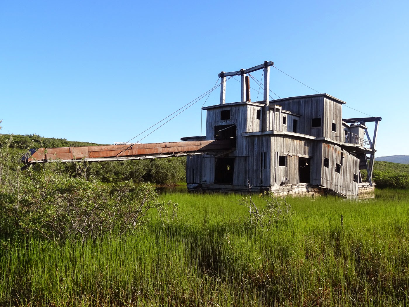
Into the Belly of the Monster

A dredge is a strange contraption, a floating excavator and sluicing plant.  It contains a belt of digging buckets that scoop up "pay" dirt and deposit it into a hopper.  The gravel is then fed into a trammel that sorts course rock from finer gold-bearing sand and gravel.  The worthless gravel is dumped directly out the back while the sediments containing the gold fall into sluice boxes.  Dredges now stand abandoned and the digging buckets make unique planters.

Digging Bucket Planter

Today the population of Nome is around 3700 and mining continues on a much smaller scale.

Another special aspect of Nome is that it is the terminus of the famous Iditarod Trail Sled Dog Race.

End of Iditarod Trail Sled Dog Race

Every year mushers embark on the 1049-mile journey from Anchorage to Nome via dog sled.  What would prompt anyone to make such an arduous journey in the dead of winter?  The answer is surprising and inspiring.  In 1925 a diphtheria epidemic broke out in Nome.  There was no easy way to get the life-saving serum from Anchorage to Nome.  The only option was to send the serum by train from Anchorage to Nenana where a relay of mushers was set up to take the medicine to Nome via dog sled.  Leonhard Seppala had already traveled 169 miles by dog sled from Nome to pick up the serum and carried it back 91 miles to the next stage.  One of his lead dogs was named Fritz.  In 1932 Fritz was brought to Lake Placid, NY for an exhibition.  He died there from old age and was taxidermied.  No one knew where he was for 73 years.  He was discovered and returned to Nome and now resides in the Carrie M. McLain Memorial Museum.
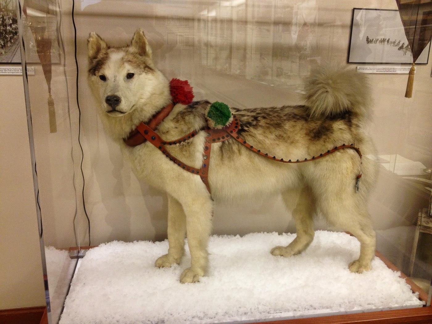
Fritz, the Famous Sled Dog

The first Iditarod was run in 1967 and was called the Iditarod Trail Leonhard Seppala Memorial Race.  Seppala had died in January of that year.  It was the 1925 serum run from Nenana to Nome that inspired today's Iditarod Trail Dog Sled Race.

Nome lies on the Bering Sea just south of the Arctic Circle, not far from here the Bering Land Bridge that once connected Asia to North America.  It was by way of the bridge that humans first arrived on the North American Continent 13,000 years ago.  Humans spread rapidly eastward and southward over the Americas as depicted in the following map.

Peopling the Americas

Many plants and other animals also moved between continents via the land bridge also called Beringia.  Three main gravel roads lead from Nome to remote villages covering 250 miles of wild lands.

The Roads (in red) we Explored

We spent the last 4 days exploring these roads in search of wildlife and to gain an insight into the subsistence way of life maintained by many native people.  Our main quarry was the muskox, a prehistoric looking beast with a shaggy coat and long curved horned.  By the end of the 19th century they were wiped out from Alaska but in 1970 thirty-four muskox from Greenland were transplanted into Alaska.  The herd has thrived and is now thought to be around 3000 animals on the Seward Peninsula.  During our explorations we encountered 3 herds ranging from 15 to 41 animals and two lone bulls.  One bull near the village of Teller was close to the road and posed nicely for us.

Muskox Bull

Not everyone in Nome is happy about the successful reintroduction of muskox.  Some of the muskox wander into town and have been known to attack and kill dogs.  As a result the muskox will be hunted for the first time this year.  Five permits have been issued.  I don't think it will be much of a hunt.  Today we spotted a small herd from the bridge crossing Bonanza Channel.  We walked about a mile and a half down the beach and came to within 150 feet of the herd.  They were not alarmed and continued to lounge contentedly on the beach.
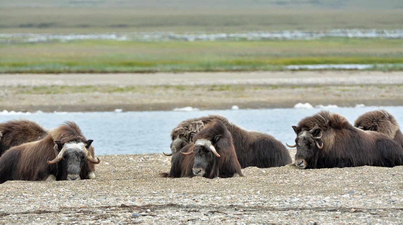

Muskox on the Beach

I felt privileged that these animals trusted us and allowed us to approach so closely.  It saddens me to know that this trust will be shattered once the first bullet is fired and the first muskox falls at the hand of man.

We did encounter a few other animals during the course of our Arctic safaris.  A lone caribou yearling was acting strangely along the banks of the Tisuk River.  She cavorted about playfully and stopped to sniff the ground like a bloodhound.  I wondered where the rest of her herd was.  Why had she been left alone?

Lone Caribou

Arctic Ground Squirrels scurried alongside the road and disappeared just as soon as we stopped to photograph them.  Finally we caught one unawares and snapped his photo.

Arctic Ground Squirrel

A Red Fox was trotting across the tundra in search of food.  He had shed most of his winter fur but his tail remained fluffy and looked ridiculously too large for his body.

Red Fox

The Bob Blodgett Nome-Teller Highway winds 72 miles across tundra to the tiny outpost of Teller. The village lies along a spit of land jutting into Grantley Harbor.

Teller

People here live a mainly subsistence lifestyle with fishing playing a main role.

Drying Fish

In May 1926, Teller made international headlines when Roald Amundsen landed here in his blimp called the Norge.

Amundsen's Air Ship

He had just made the first Arctic flight from Europe to North America!  He left Spitsbergen, Norway, flew over the North Pole and was forced to land at Teller due to weather, even though his destination was Nome.  Amundsen really got around.  He was the first to the South Pole, the first to sail through the Northwest Passage and the first to fly from Europe to North America!

So when the local claim there is no place like Nome, they're not kidding!!

We hope all is well back home,
Peggy and Marc 

Sunday, April 20, 2014

Tragedy on Everest

Greetings All,
We had one more high pass to conquer, the Kongma La, to complete what is known as the "Everest Three Passes Trek".   Most of the group opted out of climbing the third pass so one of our Sherpas, Ongchhu, accompanied us and another client over the pass.  From Lobuche we had to cross the Khumbu Glacier before starting our ascent.

Marc Crossing the Khumbu Glacier

The approach to the top of the Kongma La was straightforward and we had a good trail most of the way.  It took us three hours to reach the summit at 18,160 feet where views of a vast frozen lake and high mountain peaks lay before us.

View from the Kongma La

We didn't linger on top too long as clouds were quickly building up.  We could see Pokalade, a trekking peak, at just over 19,000 feet with its double-peaks looking close enough to touch.

Peggy on the Kongma La

We descended past the large unnamed lake to yak pastures and finally down to the Imja Valley.  We didn't go all the way to Chunking but took a steep shortcut through grassy fields to the valley floor and down to Dingboche.  We arrived just before the snow began to fall and settled into our quaint lodge. The next morning the weather had cleared and we left Dingboche under clear skies.

Leaving Dingboche

The weather remained good until we reached Pangboche where we stopped for lunch.

Peggy Approaching Pangboche

Pangboche has one of the oldest monasteries in the Khumbu and we paid it a visit after lunch.

Pangboche Monastery

A woman unlocked the door so we could go inside where burning butter lamps softly illuminated the interior.

Butter Lamps in Pangboche Monastery

We continued our descent to Deboche past porters who were still hauling up heavy loads for NBC News.  When we finally had Internet access we found that the Discovery Channel plans on airing the first wing suit flight off Mt. Everest ("Everest Jump Live") on May 11.  Climber Joby Ogwyn will make the attempt in a custom-made wing suit with cameras to capture his 10,000 foot plunge.  We figured it had to be a major production based on the tons of equipment being hauled up the mountain for a 2-hour broadcast.

Porter Hauling More NBC News Equipment

The next day we resumed our descent back to Namche Bazaar stopping to visit the famous Tengboche Monastery.

Gateway to Tengboche Monastery

The monastery is the largest gompa in the Khumbu region and was originally built in 1916.  It was destroyed by an earthquake in 1934 and rebuilt.  It was destroyed a second time by a fire in 1989 and built for a third time.  Inside the monks were preparing to resume their morning prayers.  After a quick cup of tea they began chanting in guttural tones.

Monks resuming their Morning Prayers

I wanted to stay longer but we had to continue our trek back to Namache Bazaar.  I spotted some Himalayan Tahr grazing on the slopes above the trail.  The Himalayan Tahr is a large ungulate (hoofed animal) related to the wild goat.  They allowed us to approach quite close making for a good photo.

Himalayan Tahr

We arrived back in Namche in the early afternoon in time for a cold Everest Beer!  It was nice to be back in the "beer-drinking zone" where we didn't have to worry about the adverse effects of high altitude.

Back in the Beer-Drinking Zone!

We checked into the Holiday Inn and settled into our basic but comfortable room.

Our Room in Namache

This was our first lodge-based trek (we usually camp in tents) and I was concerned about being able to sleep and stay healthy but we didn't have any problems.  I could get used to this cushy lodge-based trekking.  The next morning we headed out through the bustling streets of Namche back to the village of Phakding.

Leaving Namache Bazaar

On Day 18 of our trek we arrived back at our starting point in Lukla.

Gateway to Lukla

Upon our arrival Rinij informed us about the disaster unfolding just above Everest Base camp.  At 6:45 that morning a huge ice avalanche swept down from near the top of the Khumbu icefall killing at least 6 Nepali Sherpas.  Throughout the morning we watched from our lodge room as the rescue helicopters stopped at the Lukla airstrip to refuel as they brought the injured and the bodies of the deceased back to Kathmandu.

Nepali Army Helicopter used in Avalanche Rescue

Unfortunately the death toll has continued to rise to 13 Sherpas with 3 still missing making this the worst single climbing accident on Mt. Everest.  It was a sobering end to an otherwise great trek and a poignant reminder of the danger inherent in mountaineering.  Our deepest condolences go out to the families that lost a member on this fateful day.  I have the deepest respect and admiration for these brave men and women who risk their lives to support the hundreds of Westerners that attempt to climb Mt. Everest every year.  Unfortunately, the allure of climbing the World's highest mountain will never go away.  I will continue to spin a prayer wheel that all who make the climb will stay safe.

We hope all is well back home.
Peggy and Marc

Everest Base Camp Here We Come!

Greetings All,
The alarm went off at 4:00 AM for another early start for our crossing of the Cho La.  The climb started off gradually but there were plenty of boulders to scramble over and rockfall to avoid from above.

Ascending Cho La

We could see a long white prayer flag on a pole on top of the ridge but as we approached I could see it was a false summit.

Prayer Flag at False Summit

The climb started in earnest from this point on.  There was more boulder hopping and a few snow fields to traverse.

Final Ascent of Cho La

Finally after 4 hours we reached the top of the pass at 17,782 feet.  Once again we were rewarded with spectacular views and stopped for a lunch break before heading down.

Us on Cho La

There was a receding glacier on the other side of the pass.  Recently the approach to the east side of the pass had to be rerouted due to the unstable glacier.  If the glacier continues to recede, the Cho La may become impassable.  Fortunately, we had our micro-spikes with us which made the descent much easier.  We had to cross the glacier over steep side-slope areas where if you slipped, you could slide hundreds of feet down into a crevasse.

Descending from Cho La

Luckily we had no mishaps and we all reached Dzongla safely.  The next morning we left Dzongla under clear skies and continued our approach to the Everest Base Camp Trail.

Dzongla Tea House

We had to cross a small pass before reaching the junction with the Everest Base Camp Trail.

Junction with the Everest Base Camp Trail

It was a short 30 minutes to the village of Lobuche where we stopped for lunch.  We crossed the Lobuche Glacier and continued along the massive Khumbu Glacier.  Finally we arrived at Gorak Shep, the last outpost before Everest Base Camp.

Gorak Shep

We stayed in a crowded teahouse where the atmosphere was more like being in a ski lodge in Europe rather than just a couple of hours away from Everest Base Camp.  Marc and I set off early the next morning to explore Everest Base Camp (EBC).  We encountered porters and yaks hauling heavy loads to support the climbing expeditions just getting underway.

Hauling Loads to Everest Base Camp

Finally the tents at Base Camp came into view.  They stretched for over a mile along the Khumbu Glacier at an altitude of 17,600 feet.  Just above camp the Khumbu icefall loomed ominously, the major obstacle to conquer when climbing Everest.  There were many climbing companies including International Mountain Guides (IMG), Jagged Globe and Peak Freaks getting set up for the climbing season just ahead.

Everest Base Camp and Khumbu Icefall

We made our way toward the end of the camp where an expedition guide was leading two novice climbers to the edge of the glacier to practice using crampons and an ice ax.  I couldn't imagine learning how to use crampons and an ice ax on an ascent of Mt. Everest!

Crampon and Ice Axe Lesson

More yaks arrived carrying loads with "NBC News" stickers.  We had seen roughly 60 porters or yaks carrying loads for NBC News.  "What were they going to do with all this equipment?", we wondered.  They must be filming some sort of documentary or maybe a clip for the Today Show.

Hauling NBC News Gear

We made a hasty retreat back to Gorak Shep as the weather began closing in.  Snow began to fall and we wondered if we would be able to climb Kala Patthar tomorrow.  Fortunately, the weather cleared overnight and we were treated to sunrise over Everest as we climbed the "peak".

Sunrise over Mt Everest and Nuptse

As we neared the prayer flags on the top, the perfectly pyramidal shape of Pumori rose in the background.

Reaching Kala Patthar

We didn't dare to go to the very top as the rocks were covered in slick snow and one slip would mean instant death.  The view from our vantage point was just as good.

Us on Kala Patthar

At 18,200 feet, Kala Patthar has one of the most impressive views of Everest Base Camp and the summit of Mt. Everest beyond.  Although not a proper peak, Kala Patthar is very popular with trekkers and now on the top I can see why.  The view of Changtse, Everest and  Nuptse was breathtaking!

View of Everest and Nuptse from Kala Patthar

It was time to return to Gorak Shep where a pair of friendly Tibetan Snowcocks greeted us.

Tibetan Snowcock

We had time for lunch before heading back down to Lobuche where we would spend the night.  What a thrilling visit to Everest Base Camp!  After reading so much about the highest mountain on our planet I could hardly believe that I had finally reached Base Camp.  I couldn't imagine scaling the peak.  I was content to admire it from afar and wish those brave enough to attempt it the best of luck!

We hope all is well back home.
Peggy and Marc