Monday, July 10, 2017

Along the High Atlas - Part I

Greetings Everyone,
We're off on another grand adventure! Trekking in Morocco's High Atlas Mountains had been on my to-do list for many years and now we were on our way to Marrakech, Morocco to make this wish a reality. We left home on June 15 and flew to Marrakesh by way of New York City and Lisbon, Portugal. Upon arrival in Marrakech we were met by Hamid, our guide for the trip. We arrived a day ahead of our group and had a little time to explore this vibrant city. One of the main attractions is the Djemaa el-Fna Square and the towering Koutoubia Mosque. Being Ramadan, the square was quiet during the day but after sunset and the call to prayer it came alive with Moroccans eager for a meal after 17 hours of fasting.

Koutoubia Mosque and Djemaa el-Fna Square

The next day we met our group, a multinational mix of folks from England, Wales, Scotland, U.S., France and Chile. We set off from Marrakesh on June 18 for the starting point of our long trek along the High Atlas. We stopped in the Berber town of Azilal. While Hamid was buying supplies we explored the market where everything from vegetables, fruit, nuts, meat, clothing and housewares were for sale.


Market Day at Azilal

We were surprised to see White Storks nesting on the minaret of a local mosque. I thought they bred in Europe and spent the winter in Africa. Morocco must be at the southern end of their breeding range.


White Storks at Azilal

For our first night we stayed in a traditional Berber gite or guest house in the tiny village of Iskataffen situated in the Bou Gemmaz Valley. Here people lead a peaceful life growing crops of apples, walnuts, wheat and barley and raising herds of sheep and goats.


The Village of Iskataffen

Early the next morning we were eager to set off on our 18-day trek. We met our trek crew composed of Mohamad our cook, his assistant Mohamad 2, five muleteers: Amgon, Abdoul, Yamine, Ali and Salah and 7 mules. We headed down valley and took a short detour to a Kasbah perched strategically on a hill with a commanding view of the entire Bou Gemmaz valley. 


View of the Bou Gemmaz Valley

Inside the Sidi Mouza Kasbah a Berber man and boy were brewing tea for their foreign guests. As my eyes grew accustomed to the dim light I could see a bag made from goat skin, wool pants made for a very tall man, the wooden butt of a rifle, a grinding stone, lanterns and shoes made from old tires. 


Inside the Sidi Mouza Kasbah

A Kasbah is a small fortress used to protect food from raiding neighbors. This Kasbah is one of the only round ones in this area and is 300-400 years old.


Sidi Mouza Kasbah

We continued down the valley before veering off to the south and up the Arous Valley. We stopped at the last village of Ayt Sayd for lunch. We were entertained by the village kids who were playing in the river, singing songs and blowing whistles. After lunch we followed the Arous canyon stopping briefly at a tea house before making the climb to our first campsite at the seasonal grazing encampment of Azib Ikkis. Our crew had already erected a cook tent, a mess tent and our sleeping tents. We got set up just as a thunderstorm hit the valley.


Our First Campsite at Azib Ikkis

Our second day of trekking took us over 2 passes: Tizi n-Oumskiyk at about 9600 feet and Tizi n-Tarkeddit at 10,700 feet. Far below we could see the Tarkeddit Plateau, our destination for the night and the starting point for our first climbing objective, Jebel Mgoun.


View from the Tizi n-Tarkeddit Pass

We headed down onto the plateau where Berber shepherds were grazing large flocks of sheep and goats. Camp had been set up in the center of the plateau near a refuge that provided hot showers and toilets to trekkers and climbers.


Our Camp on the Tarkeddit Plateau

When we rose early the following morning for our climb, Venus had risen over a crescent moon creating a surreal scene. 


Venus with a Crescent Moon

We headed out in darkness using our headlamps to light the way. We contoured up on switchbacks as the sun rose reaching a plateau before the steep climb to the ridge.  When we reached the long summit ridge we were hit by a fierce wind. I was concerned about being blown off the narrow ridge but we managed to keep our footing. We could see the summit of Mgoun looming ahead, it was not far to go now.


Approaching Mgoun

We arrived at the summit around 9:40 and lingered long enough to enjoy the view and take a group photo. We wanted to be off the ridge long before any anticipated thunderstorms.


Mgoun Summit

We returned to camp 9 hours after we had set off. That night we fell asleep to a cacophony of sounds; barking dogs, tinkling frogs, braying donkeys and bleeting goats and sheep.

We left the plateau the following morning and climbed to a higher plateau called Tizt N'Asdrem where more Berber nomads were living in summer encampments grazing their sheep and goats. We continued to a viewpoint at the edge of the plateau where we could see the village of Tasgarnalte far below surrounded by irrigated fields of wheat, barley and potatoes. The hills were different hues of red, purple and yellow.


Viewpoint Over the Village of Tasgarnalte

After our break we continued steeply down through a broad canyon whose slopes were covered in purple and yellow-flowered scrubs. These were among the only plants to survive the ravenous goats and sheep because I thought they were unpalatable. However Hamid told us that the livestock will eat the flowers but have not grazed this area yet.


Flowering Shrubs 

We switchbacked down slippery scree to an area of massive, ancient juniper trees where we stopped for lunch. After lunch we continued down past village fields of barley that had been planted in March and would soon be ready to harvest. We passed through Tasgarnalte Village and on the other side camp had been set up in the front yard of a local family.

The next morning we continued our trek past Berber villages now connected to the outside world by a new road. The local women were carrying heavy loads of fodder on their backs. After many years of this hard labor many of the older women were permanently bent over.


Heavy Loads of Fodder

We left the road and climbed above the river to the village of Azib n'Ikkis where there was a Kasbah made of stone and wooden beams.


The Kasbah of Azib n'Ikkis


We climbed higher reaching another village called Ichbbakane where we stopped to admire the mosque with its square minaret. Hamid told us that Morocco is the only Islamic country whose minarets are square. In much of the rest of the Islamic world, minarets are round as an artifact of the Ottoman Empire. The Ottomans never conquered Morocco, hence the square minarets remained. On top of the minaret were three balls representing the three main religions Judaism, Christianity and Islam and their common origin. The crescent moon on the very top points to Mecca. 


The Minaret at Ichbbakane 

We continued our climb until we reached the last house where a barking dog was chained. It's owner stood nearby until we safely passed. From the top we contoured back down to the river which we had to cross to reach our lunch spot. After lunch we recrossed the river and followed the streambed passing a few more villages. Finally after 9 long, hot hours we reached the village of Ait Ali Nitto where we spent the night in Gite D'Etape Assounfou.


The Gite at Ait Ali Nitto

The next morning we followed the road out of town passing a day market where only men were setting up shop.  At the end of the road was the picturesque village of Megdaz.  We climbed above to get a view of the village with its five kasbahs and two mosques, one old and one new with their minarets.

The Village of Megdaz

We continued climbing to Tizi Awrghiz where we got our first view of our second climbing objective Jebel Anghomar. We contoured around the base of a cell tower before heading down to a dry riverbed and walked along it to the village of Tagoukht where we had lunch serenaded by the village boys.

View of Jebel Anghomar from Tizi Awrghiz

After our lunch break we passed back through the village then up once again through a sparse forest of juniper trees. We generally climbed but sometimes had to descend to cross a gully.  Finally we could see camp above but had to cross a deep ravine to reach it. This could be the last night of Ramadan, depending on if the new moon would be seen early the next morning. 

The crew was up at 3:00 AM so Ramadan had not ended. I couldn't imagine trekking all day in the hot sun with nothing to eat or drink but that is what our crew had been doing. We hiked down to a road on the border between the provinces of D'azilal and Ouarzazate. We could see a village and Jebel Anghomar looming above far across the valley. We began a long climb up toward a red plateau which we contoured past. The landscape was rocky and barren, yet sheep and goats are grazed here.  I struggled to keep up with the group as we made our final climb up to Tizi n-Tghaghayt.  We stopped for a break and we could see Lake Tamda far below.  It's one of the only permanent freshwater lakes in the High Atlas.


View of Lake Tamda

We descended to a dry riverbed and followed it toward the lake where four Ruddy Shelducks were bobbing on its surface. 

Ruddy Shelducks


After dinner Hamid told us the climb tomorrow of Jebel Anghomar would be difficult.  Few trek groups tackle the peak and there's no established trail. The route follows a steep gully with rocks.  The descent would be on loose scree. We decided not to go. The rewards didn't outweigh the risks.  

We heard the others get up for breakfast at 5:00 AM in preparation for their climb. Part of me wanted to go with them but I knew my knees and bruised toes could not handle a steep, fast descent. We along with the others not making the climb left camp at 7:00. On the way out we had to be careful not to step on the hundreds of tiny African Green Toads at the edge of the drying pool in front of our tents.  

African Green Toad

We passed the Ounila Stream, our water source, and headed straight down the valley. Once again we hiked through a rocky, barren landscape where the occasional Berber shepherd was tending his flock of sheep and goats. The muleteers and mules finally caught up to us.  One of the mules had cut his leg badly and some in our group helped the muleteers tend his wound. We reached the confluence of a fast flowing stream called Tichkiwiyn. Along its banks grew trees with colorful pink flowers called Common Oleander. 


Common Oleander along Tichkiwiyn

Further down the trail we spotted at least 3 squirrels with stripes scamper up the rocks. They turned out to be Barbary Ground Squirrels, the only squirrels that live in Africa north of the Sahara.

Barbary Ground Squirrel

We continued along the stream until we reached the village of Tighza and our welcoming gite. The rest of the group arrived after lunch tired but happy that they had climbed the peak. 

Tonight the gite staff prepared and served us dinner.  We had soup served with funny wooden ladle-like spoons and chicken and vegetables cooked in a tagine, an earthenware pot.

Tagine

We started trekking around 7:40 the next morning. We hiked through town and left the road to join a trail marked for the Trans-Atlas Marathon (TAM), a race of 280 km. We climbed up to a barren, rocky plateau where even goats and sheep don't graze, then down to a road and veered off to go overland.  There were many small depressions that appeared to have once been filled with water but there were too many to be natural. They turned out to be formed by people mining salt. We continued down to a dry riverbed where lunch had been set up under some poplar trees. After lunch we quickly reached the village of Telouat to visit its famous kasbah. From the outside the structure looked like crumbling mud brick walls but inside were architectural wonders. 

The Kasbah at Telouat

The Kasbah was more than a fort, it was the palace of the El Glaoui family. The head of the family became fabulously wealthy by forcing all the salt caravans from Timbuktu to Marrakesh through his kasbah.  No doubt he charged them a pretty penny to spend the night.  Upstairs were the ornate rooms where the king-like Glaoui elder housed his harem. The walls were adorned with mosaics, painted wooden doors and windows and carved plaster above the tile. 

Inside the Kasbah at Telouat

Unfortunately the people of Telouat don't want UNESCO to restore the Kasbah. We climbed to the roof for a last view of the Kasbah. Thunder was rumbling in the distance so we didn't stay long.


Rooftop View of the Kasbah at Telouat


We left and headed toward irrigated fields above town and arrived at camp about an hour later. After 9 hard days on the trail, we're half way through the trek. We've covered 101 miles, climbed 23,000 vertical feet including Jebel Mgoun, the 3rd highest peak in the range, visited many Berber villages and old kasbahs. Stay tuned to see how we fare during the second half of our trek along the High Atlas!
We hope all is well with everyone.
Peggy and Marc

Our route map:


Wednesday, April 05, 2017

If Only the Moais Could Talk

Greetings Everyone,
It's hard to imagine a place so remote that the nearest continental point is 2182 miles away! A place where stone giants line the seashore gazing out at open ocean that stretches forever. Rapa Nui is that place and on March 25 we set out to visit this almost mythical island known by most as Easter Island. The first European to set foot on the island was Jakob Roggeveen who landed on Easter Sunday, 1722 giving Rapa Nui its more common name, Easter Island. Today it's much easier to reach in a Boeing Dreamliner that flies daily from Santiago, Chile to this remote locale.


The Island looks a lot different today than in 700 to 1100 CE when the first Polynesians arrived in their outrigger canoes from the Gambier or Marquesas Islands. Back then the Island was forested with palm and Toromiro trees which are now extinct in the wild. Efforts to replant the Toromiro have failed as the soil and climate are no longer ideal for them.  Today the Island consists mainly of open grasslands with a few groves of introduced eucalyptus trees.


Easter Island Landscape

We were met by our tour guide, Josie, and checked into our hotel before making our first excursion to the ceremonial site of Ahu Tahai close to the only town, Hanga Roa. It's hard to describe one's feelings when you see these monoliths for the first time.  Wonder and awe come to mind.  How could ancient peoples carve and transport these massive stone statues with only primitive tools?

Moai Carving Tools

This site contains three stone platforms called Ahu which support the statues which are called moais. The largest platform, Ahu Tahai, contained 5 moais each carved from compacted volcanic ash called tuft.  The largest stands 30 feet tall and weighs 80 tons!  


Ahu Tahai

Nearby was a smaller Ahu with a single Moai, Ko Te Riku, with restored eyes made from white coral and red scoria.  This moai had what looked like a top hat also made of red scoria.  Josie explained that it is a top knot or putao and is thought to be hair fashioned in the style of the day.

Ko Te Riku

Josie took us to the nearby grave of Dr. William Mulloy, an American anthropologist, who was responsible for restoring this site in 1974. She added that Dr. Mulloy was her maternal grandfather! How wonderful to have Josie who has a very personal connection to the island, as our guide!

Josie at the Grave of Her Grandfather, Dr. William Mulloy

We visited a second site called Ahu Akivi, (which Dr. Mulloy also restored) an inland grouping of 7 moai all looking out to sea.  Legend has it that a priest, Hau-Maka, had a dream in which his spirit traveled far looking for a new land for his king, Hotu Matu'a. When he awoke he told the king about this new land and scouts were sent to locate it. Seven remained behind to await the arrival of King Hotu Matu'a and the statues at Ahu Akivi were erected in their honor.

Ahu Akivi

The next morning we visited Anakena, a white coral sand beach thought to be the first landing site on the island.
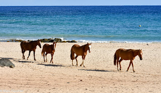
Horses at Anakena

Nearby was Ahu Nao-Nao with 7 moais, 4 with pukao.  At this time of the day it was a peaceful place and I wondered what the first Rapa Nui thought as they landed on the beach in their canoes after crossing thousands of miles of open ocean! How long had they been at sea and what hardships did they have to endure before arriving at this place?

Ahu Nao-Nao

Our next stop was Te Pito Kura, an unrestored site.  I was shocked to see a single moai that had been deliberately pushed over. The statue laid face down in two pieces on the ground.  It was the largest moai transported from the Rano Raraku volcanic quarry and successfully erected on an Ahu or platform.  Its height reached 10 meters or 33 feet and it's estimated weight exceeded 80 tons!  Who would have caused such vandalism to a once sacred site?

Te Pito Kura

Josie went on to explain that in fact all the erected moais on the island had been toppled between 1722 and 1868 by the progeny of those that created them. I had no idea.  What could have caused the people of Rapa Nui to destroy what was once believed to be the embodiment of their ancestors containing mana, a supernatural power meant to protect them?  Internal warfare is thought to be the answer.  As the population of Easter Island grew and natural resources depleted, the Rapa Nui began fighting among themselves with one clan toppling the moais of another to weaken them. The arrival of the first Europeans and the emergence of a new religion called the Birdman Cult probably contributed to the destruction of the moais.  

Nearby is a large ovoid-shaped rock purporting to have been brought to the island by Hotu Matu'a and like the moais contains supernatural power or mana. The name Te Pito Kura means "navel of light" and this stone is also referred to as Te Pito O Te Henua ("navel of the world").

Te Pito O Te Henua ("navel of the world").

Probably the most famous site on Easter Island is Ahu Tongariki with its impressive 15 standing moais!  

Ahu Tongariki

Restoring Ahu Tongariki was no easy feat.  The statues, some weighing up to 80 tons, were not simply toppled over but moved hundreds of feet inland by a massive tsunami that hit the island in 1960!  The 26-foot high tidal wave was caused by the most powerful earthquake ever recorded centered around Valdivia in Central Chile.  I talked about this earthquake in a previous post titled "The Many Surprises of ChiloĆ©!".  The impetus for restoration came from an unlikely source, Tadano, a Japanese company that makes trucks and cranes.  They demonstrated back in Japan that an 11-ton replica of a moai could be lifted by one of their cranes.  In June of 1992, a crane capable of lifting 15 tons arrived by ship all the way from Kobe, Japan!  A team of Chilean, Polish and American archaeologists was formed and restoration was completed in September, 1996. Today thousands of tourists travel to Easter Island to see this impressive site particularly at sunrise when rays of sunlight illuminate the resurrected figures.

Ahu Tongariki at Sunrise

If only the moais could talk they would tell us where and when they were created. We know from carbon dating that they were carved between 1100 and 1600 A.D.  Most of the moais were carved insitu at Rano Raraku Volcano, a seemingly inexhaustible source of volcanic tuft. There are around 400 statues still at the quarry, half of which were completed but never transported to an Ahu.

Moais at Rano Raraku Volcano

The Rupa Nui were in the process of carving the largest statue, a monstrous megalith called El Gigante (The Giant), which was almost 71 feet tall and weighed 175-200 tons!  He was never completely cut from the mountain maybe because the clans had already started warring or maybe because his creators realized he was just to big to transport and erect.

El Gigante (The Giant)

How on Earth did the Rupa Nui get the statues them from the quarry to an Ahu up to 12 km away? If the moais could speak maybe they would confirm one of the popular theories proposed over the years. Were they placed on logs and rolled to their destination?  This may help explain why the island was deforested. Or maybe the trees were felled to build sledges to pull the moais to their waiting platforms. Another theory suggests that the moais were made to "walk" through the use of ropes. We may never know the truth which adds to the mystic of the island and its stone giants.

Theories of Moai Movement

The next day Josie took us to the village of Orongo.  High above the Pacific, Orongo is the ceremonial centre of the Birdman Cult.  We passed a collection of low, sod-roofed, windowless stone houses which were used to provide refuge for meditating members of the Birdman Cult. Every September the cult members would eagerly await the arrival of Sooty Terns to a nearby islet marking the beginning of the annual egg hunt.  Whoever brought the first egg back undamaged would bring mana to his chief and clan.  To reach the islet meant a 300-foot climb down a barren cliff face to reach the ocean and a swim on a reed mat through a thundering surf.  Once on the islets the hunters had to wait for the birds to arrive and lay their eggs.  


Orongo

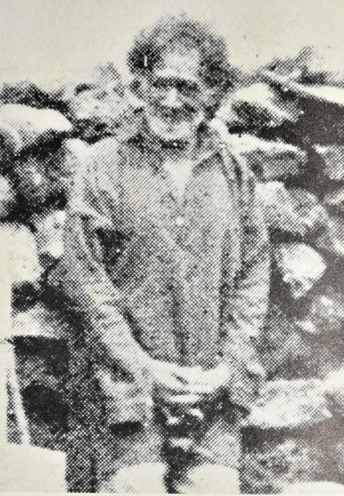
Had the Birdman Cult ritual replaced the need for the moais to provide mana and ultimately led to their destruction?  Only the moais know for sure, if only they could speak.  However the power of Orongo also came to an end. In the 1860's most of the Rapa Nui had died of disease or were enslaved by Peruvian slave raiders. In 1862, 1500 men and women (half the island's population) were captured and taken to Peru.  Of the 3000 total Polynesians and Micronesians taken only 148 were repatriated and of these only 37 to their home island. Josie told us that her great-great grandfather was among the lucky few who were taken and later returned to Easter Island.  She lent me a book entitled "Slavers in Paradise" by H. E. Maude. On page 168 there was a photo of Josie's great-great grandfather Pakamio Maori taken on June 30, 1889!  

Pakamio Maori, from "Slavers in Paradise" by H.E. Maude

Josie's great-great grandmother was an equally colorful character. Josie told us that Angata was married to a cruel man who beat her so much that he broke her back.  The next day he mysteriously died. Angata married Josie's great-great grandfather Pakamio and lived for many years after his death. She was still alive when British anthropologist and archeologist Katherine Routledge arrived on Easter Island in 1914. Angata was described as a cathechist and visionary in Katherine's biography "Among Stone Giants" written by Jo Anne Van Tilburg.  Angata tried to get on Katherine's good side by bringing her chickens and other gifts but she had an ulterior motive.  She was hoping that Katherine would intervene on behalf of the natives against sheep farmers who had taken over the island.  Angata was respected but her spooky behavior led many to fear her as a witch. Although Routledge initiated the first true survey of Easter Island, she never published her scientific findings. After returning home she was plagued with mental illness and institutionalized by her family. Van Tilburg told Josie on one of her visits to Easter Island that Routledge believed Angata had put a curse on her! Josie's connection to Rapa Nui really brought the history and culture alive for us!  We treasured the intimate stories she told us.


Angata, from "Among Stone Giants" by Jo Anne Van Tilburg

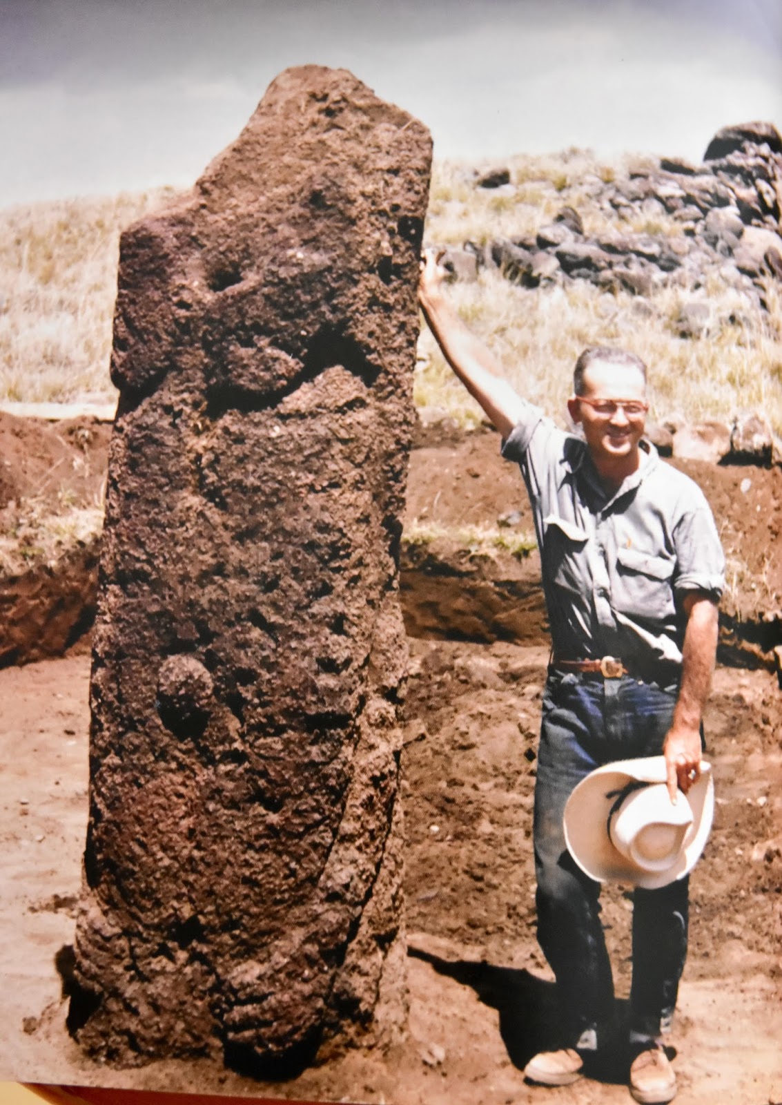
After our visit to Orongo, Josie took us to Vinahu, another site her grandfather William Mulloy restored.  During the 1955 Norwegian Archaeological Expedition, Dr. Mulloy found one of only two female moai.


Dr. William Mulloy at Vinahu, from "1957 Thor Heyerdahl Expedition"

Today the statue looks a lot different.  With all the lichen growing it's difficult to see the breasts which define this statue as female.

Female Moai at Vinahu

The following day we visited another unrestored site called Ahu Akahanga.  It's still shocking to see the moais in a toppled state.  Ahu Akahanga is unusual in that one of the moais was felled face up.

Ahu Akahanga

Ahu Akahanga is also known as "The King's Platform".  Legend has it that the Island's first ruler, King Hotu Matu'a, had a spat with his wife and left Anakena Village to live out his final days in Akahanga where his sons buried him.  Archaeologists have yet to find his tomb.

We had lunch at La Kaleta Restaurant.  Located at the Hanga Roa Wharf we had a seaside seat where we could watch the surfers catch a wave.

Hanga Roa Surfer


Nearby, Green Sea Turtles glided around the docked boats looking for a handout from the local fishermen.


Green Sea Turtle

That night we were entertained by a Kari Kari Dance. With a Polynesian flare the women shook their hips with an unbelievable fast tempo while the men thrust their hips dressed in only a loin cloth. For a moment I thought I was at a Chippendales Show (not that I've been to one)!

Kari Kari Dance

During our final morning on Rapa Nui we took in one more sunrise at Ahu Tongariki. When we arrived a crescent moon hung over the forgotten ancestors as the first rays of sunlight illuminated their dark forms.  I couldn't help thinking of the commemoration on Dr. William Mulloy's grave, "By restoring the past of his beloved island, he also changed its future". While tourism certainly has provided the people of Rapa Nui jobs and secured an economic future, care must be taken to control the number of visitors so as to not overstress the limited resources on this remote island.

Moon Over Ahu Tongariki

Thanks to our wonderful guide, Josefina Nahoe Mulloy (Josie), whose intimate connection to the island gave us insights that most tourists aren't privy to.  You brought the past of Rapa Nui alive and are a shining example for the future!
We hope all is well with everyone,
Peggy and Marc

Our route map: