Greetings All,
Our trek through Los Nevados National Park ended in the colorful colonial town of Salento in the heart of Colombia's coffee growing area. We were picked up in vintage Willys jeeps which were built from 1941-1945 to be used as WWII utility trucks and driven to a nearby coffee plantation.
 |
| Willys Jeep Ride |
Colombia is the third largest producer of coffee in the world after Brazil and Vietnam. Here at Finca El Ocaso Salento coffee is grown at nearly 6000 feet above sea level (considered mountain-grown) giving it specialty coffee status. The process starts with planting the coffee beans in river sand.
 |
| Planting Coffee Beans |
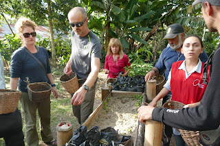
The plant reaches maturity after 18 months when it blooms for the first time. The coffee fruit, called cherries, starts out green and after 9 months the fruit ripens to a vibrant red and is ready to be picked by hand.
 |
| Coffee-picking "Recruits" |
Coffee plants produce twice a year for 5 years. The coffee beans are extracted from the fruit by a process called milling then washed and dried. The beans are finally roasted and ground producing what we now recognize as coffee.
 |
Coffee Cherries to Ground Coffee
|
Salento is a cute town with brightly painted houses, shops selling local crafts, restaurants and of course a picturesque church in the town square.
 |
| Colorful Salento |
 |
| Church of Our Lady of Carmen |
Early the next morning we flew back to Bogotá for a city tour. We visited the historic old city known as La Candelaria. There was a time when this area was too dangerous to visit. Now the neighborhood is safe and trendy causing real estate prices to soar. For the most part the graffiti has been replaced with colorful murals.
 |
| Street Murals in La Candelaria |
The main square, called Bolivar Square, was full of people out for a Sunday stroll or bike ride.
 |
| Bolivar Square |
Our last stop was the Gold Museum. The museum has on display 6000 pieces of pre-Columbian artifacts, most made with gold.
 |
| Pre-Columbian Artifacts |
We left Bogotá at the crack of dawn the following morning to visit the world famous Caño Cristales. To get there is quite a process. We arrived at the main airport where several groups of people met. Our names were called from a list and we were allowed to board a bus and driven to the military base on the other side of the airport. Here we were weighed along with our bags and had to wait for the weather to clear in La Macarena or so we were told. A third bus arrived with a man in uniform and suddenly we were allowed to board our plane, a twin prop which carried about 20 passengers. The flight took only an hour and we were mainly in the clouds. When we landed the man in uniform was greeted and photographed by other soldiers. Apparently he is a high ranking officer. There is a heavy military presence here. During the final years of the civil war (1999-2002), La Marcarena was part of the FARC guerrilla El Caguán DMZ (demilitarized zone). Today peace has been restored and the soldiers don't mind posing for photos with tourists.
 |
| Soldier and Peggy in Macarena |
Visits to the river of Caño Cristales, also known as "The Crystal Spout" or "Liquid Rainbow", are tightly controlled to protect this fragile environment. Only a certain number of tourists are allowed in a certain area on a given day. Today the quota must have been met as we had to visit an alternate area. We climbed to a mirador (lookout) over the Guayabero River and crossed a plateau to reach a smaller tributary of Caño Cristales called Cristalitos. The unique Vellozia plants have adapted to growing on the nutrient poor solid rock surface of the tableland and are resistant to fire.
 |
| Vellozia Plants at Mirador |
Cristalitos flowed raspberry-pink due to an aquatic plant growing in the riverbed.
 |
| Cristalitos |
At first I thought the plants were an algal bloom but the water is crystal clear and nutrient poor. Macarenia clavígera is actually an endemic plant species in the riverweed family with specially adapted roots to cling to rocks in fast flowing water.
 |
| Macarenia clavígera |
The next day we were allowed to visit Caño Cristales and explored 5 branches of the river system. Caño Cristales drains the quartzite tableland of the Serrania de la Macarena mountains formed approximately 1.2 billion years ago. They are a western extension of the Guiana Shield in Venezuela, Guyana, and Brazil and are among the oldest exposed rocks in the world. The river flowed over the rocks creating many waterfalls, rapids and potholes called "giant's kettles". These circular pits are formed when harder rocks get trapped in cavities and scour out the softer rock in a circular motion.
 |
| Potholes in Caño Cristales |
We carefully made our way downriver on slippery wet rocks stopping to admire the many waterfalls cascading over staircased-rocks into crystal clear pools.
 |
| Casada Piedra Negra |
At a few points we actually had to cross the river but our local guide Walther was there to lend a helping hand.
 |
| Peggy Crossing Caño Cristales |
Back at our hotel we were treated to a dinner of traditional cuisine and entertained by local dancers and musicians. The music and accompanying dance called the joropo originated in the llanos (plains) of Venezuela and Columbia with African, native South American and European influences. The dance involved a lot of foot stomping and twirling of the young women's colorful skirts.
 |
| Joropo Dance |
We flew back to Bogotá on July 13 to prepare for the next chapter of our Colombian saga, a 12-day tour to look for some of Colombia's 1900 species of birds! Stay tuned to see how many we find.
We hope all is well back home,
Peggy and Marc
Our route:
 |
| Our Route |


No comments:
Post a Comment